

Marble Imaging Raises Additional €6Mn to Build Germany’s Commercial Satellite Network
Nov 9, 2026 | By Oliver Bennett

German space technology company Marble Imaging has raised an additional €6 million in funding. The investment was led by Cherry Ventures and adds to the company's earlier €5.3 million seed round, which was led by High-Tech Gründerfonds.
SUMMARY
- Marble Imaging raised an additional €6 million in funding led by Cherry Ventures.
- The investment extends its earlier €5.3 million seed round led by High-Tech Gründerfonds.
- Established in August 2023 in Bremen, Germany.
 Follow us
 Follow us
Founded in August 2023 in Bremen, Germany, Marble Imaging works in the Earth observation (EO) sector. The company is building a network of very-high-resolution (VHR) satellites to capture detailed images of Earth.
Marble Imaging aims to provide Earth observation data as often as every hour. Its satellite network and data analytics will help customers access timely information about changes on the planet and make decisions when time is critical.
"To make better decisions, data access must be immediate and actionable," says Robert Hook, co-founder and CEO of Marble Imaging. "Europe and many of its global partners lack this capability today. We at Marble are determined to close this gap, and Cherry's trust helps us achieve this faster."
RECOMMENDED FOR YOU

ANYbotics funding news – Zurich-based ANYbotics has Secured an Additional €57 Million Funding
Kailee Rainse
Dec 13, 2024
FireDrone Raises €161K From Venture Kick To Develop Heat-Resistant Drones
Kailee Rainse
Nov 3, 2025

Czech startup Grid.online Raises €4 Mn in Round led by DFF Ventures
Oliver Bennett
Jun 22, 2026
Marble Imaging is developing Germany's first commercial network of very-high-resolution (VHR) satellites. These satellites will capture highly detailed images of Earth, which are important for security and business intelligence. Currently, Europe and its partners rely heavily on satellite data from providers outside the region. This can create problems if access to important areas is restricted, as seen during the war in Ukraine and tensions around the Strait of Hormuz.
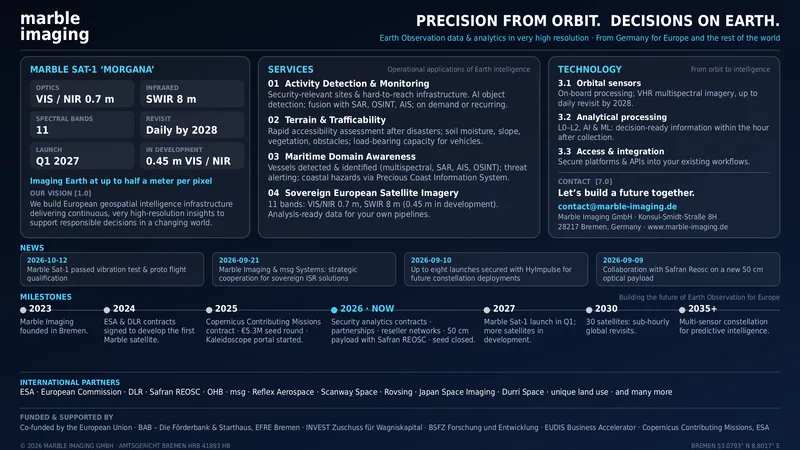
Marble Imaging's satellite data and analysis services will help organisations make faster decisions during important situations. The information can support defence, climate security, crisis response and disaster management. It can also help with renewable energy projects, infrastructure development and transport planning.
The company already provides several services that turn satellite images into useful information. These include detecting objects for security monitoring, studying land and terrain, and assessing whether areas can be accessed by vehicles.
Marble Imaging also offers services to monitor coastal infrastructure and track changes in land use. Its technology can help organisations understand what is happening in different locations and respond more effectively to changing conditions.
Read Also- VÆRIDION Secures €124M to Advance AI-Powered Regional Electric Aviation in Europe
Recommended Stories for You

Oliver Bennett Nov 22, 2023

Capmont Technology funding news – Munich-based Capmont Technology Secures €100 Million in Funding
Oliver Bennett Sep 19, 2024

Oliver Bennett Oct 4, 2024

Kailee Rainse May 7, 2025

Sirius Game closes €1.3 million round: the EdTech startup making learning more effective through play
Oliver Bennett Jun 15, 2026
Kailee Rainse Sep 9, 2025
Trending Stories

WilsonAI funding news – London-based WilsonAI Secures €1.6 Million in Pre Seed Funding
Verretex funding news – Switzerland-based Cleantech Startup Verretex Secures €159k in Funding
CDTM Venture Fund funding news – Munich-based CDTM Venture Fund Secures €8.2 Million to Support CDTM-affiliated Startups

PanTera Funding News – PanTera secures €93 Million Oversubscribed Series A Funding

VERIGRAFT funding news – Gothenburg-based VERIGRAFT Raises €1.2 Million in Funding

Telescope funding news – PropTech Startup Telescope Secures €3.7 Million in Seed Funding
Matrix Renewables funding news – Madrid-based Matrix Renewables Secures €50Million Green loan

Fleek funding news – London-based Fleek has Secured $20.4Million in Funding